
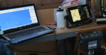
In 2016 we decided to take the boat back to the UK and subsequently found a tidal mooring in Suffolk. Then we had to get the boat to the north coast, through some busy waterways and across the North Sea. European regulations stated that we had to have an AIS class A system because we are over 20m in length. AIS would also be useful for the busy shipping lanes of Dover Straits, southern North Sea and Thames estuary. It cost around £1000, the broadband radar plus 9” display was around £1500 and the Nautronics chart chip was £150 (all excluding VAT). This would all be very useful for future trips across the Thames estuary as well.
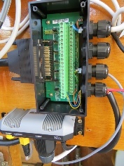
The AIS was an ‘AIS Carbon Pro’ from Digital Yacht and came with the main receiver/display unit (bottom right in the picture to left) an interface box (top of the picture to right, shown with the cover open) and a dedicated VHF antenna. It was connected to our 24v supply via a 5A fuse and interfaced to both the Simrad multifunction display via RS422 and the navigation laptop via RS232.Here are the technical details as a manual in pdf format.
A Blue board function was also enabled by connecting the AIS to a relay that gave a short circuit when 12v was switched to the flashing light on the blue board. The relay was hidden behind the console and connected to the AIS interface box. When triggered, the AIS would then transmit our blue board status to other barges so that they would see it on their AIS displays. We used this several times en route to the coast as we met large commercial barges carrying out unusual manoeuvres and blocking the normal ‘port to port’ option for us to pass.
We bought a Simrad 3G radar with an evo2 NSS9 9” multifunction display (see manual & description), rather than a dedicated radar display. This had the advantage of also being a touch screen navigation plotter if we bought a chart chip to go with it. We thought this would be more robust and intuitive to use than buying a charting package for a windows based laptop (laptops can crash or fail at inconvenient times). The laptop was still used for PC Navigo inland waterways navigation and as a simple AIS display when at sea.
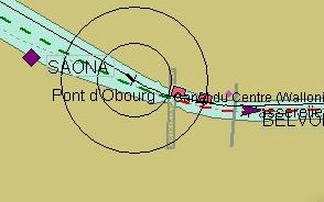
Below left you can see Waterdog, shown inside the 2 concentric circles, has just passed port to port with a large commercial barge going around a bend in the canal (commercial barge shown as purple arrow head) and a moored barge (shown as a purple diamond) on the left bank ahead of us, Waterdog is going towards the top left.
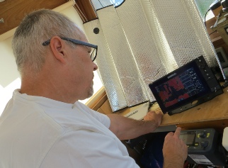
The Simrad display can either be full size radar/chart plotter as below right or as a split screen between navigation plotter and radar.
We used it in split screen mode for nearly the entire sea crossing as radar proved to be very useful, even in good visibility, for assessing close quarters with other vessels.